Recent Publications |
|
|
 |
|
|
|
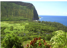
Thematic Areas - Coastal Shelterbelts
|
| |
Definition |
| The natural or manmade sources, which can dissipate or deflect the potential wind and wave energy and protect the coastal life and properties from the calamities, are called as coastal shelterbelt. |
|
What are Shelterbelts? |
Natural disasters like tsunamis, storms, cyclones, coastal erosion, typhoons, sea level etc causes damages to coastline of the world. The above natural phenomena devastate the human lives, livestock, trees & forests demolish constructions, welfare structures, Loss of agriculture land, aquaculture, saltpan, coastal land, beaches, tidal land etc. Since cyclones and tsunamis mostly originate from the sea and move towards the land , the wind – generated reduced , reflected , deflected and dissipated, when they pass through obstacles such as coastal forest, mangroves, offshore islands, coral reefs, head lands, sea cliffs, sand pits, mud flats, sand dunes, creeks etc. Other than the above natural features, man made structures along the coastal line such as offshore platforms, sea wall constructions, harbour and plantations also help in energy dissipation. The information related to the importance and distribution of coastal shelter belts along the coastal line of India is presented here.
www.iomenvis.nic.in |
Bio-shields |
A 'bio-shield' formed by planting a vegetation belt along coastlines would protect India against future coastal storms, cyclones and tsunamis.
The plantations could play a double role. While absorbing the force of severe storms and tsunamis, the 'bio-shield' could act as a 'carbon sink' by absorbing emissions of the greenhouse gas carbon dioxide.
Another key recommendation is to help local communities build artificial coral reefs, among which fish could shelter and breed.
|
|
Types of Shelterbelt |
Hard Defenses
Static shoreline structures such as those constructed from timber, steel, concrete, asphalt and rubble. These involve linear structures such as sea walls, revetments and control structures of artificial headlands, offshore breastwork and groynes.
Soft Defenses
Mobile/ responsive defense measures, seek to work with nature rather than control it. Such structures may consist of sand or shingle beaches and dunes or banks, which may be natural or constructed, and may include control structures. These can include soft solutions of beach nourishment, cliff/dune stabilization, bypassing and managed retreat.
Reference
Dr.Ramesh.R. and Dr.Purvaja Ramachandran. 2007,’ENVIS – MoEF on Coastal Zone Management and Coastal Shelter belt Vol(6)’,pp 25.
|
Coastal Vegetation
|
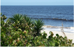 |
A recurring pattern of dune, clifftop, mangrove and saltmarsh plant communities characterizes many rocky coasts. The plant communities comprise a diverse variety of plant species representing a number of plant families. In general, the plants are adapted to cope with the hot, dry conditions and saline environments. The communities form important habitat for a variety of native fauna. They also have a very important role stabilizing and trapping marine sediments and forming a protective buffer between the land and the sea |
|
|
Many unique plants are found in dunes, coastal wetlands. Each plays a significant role in the ecology of the coast. Understanding the role and function of these plants helps to better understand the need to conserve these plants and their habitat. Salt marshes (in the temperate regions) and fore-dunes form a major part of coastal zones and are under the direct influence of seawater. Salt marshes consist of alluvial sediment deposits ranging from sandy to muddy substrates, which are flooded with seawater. Daily inundations with seawater following the tidal rhythm may take place, with the lower parts flooded more frequently and for longer periods than upper parts. Depending on the length of the period of seawater inundation and soil characteristics, including its mineral composition and microbial activity, the oxygen content and the redox potential of the soil falls.
On soft muddy substrates, higher plant life (Zostera) often starts below the level of the mean high water neap tide, sometimes mixed with pioneering Salicornia and Spartina. On slightly higher levels (sometimes only a few cm) other species occur. A sequence of belts with different salt-marsh species from lower to upper levels occurs. The direct influence on the seawater stops where litter deposited during winter storm surges forms a strandline. The influence of salt spray deposition may reach much further inland; it is most important for the development of the dune vegetation.
In India, coastal forests are restricted to the rainy parts of the Western Coastal plains and the Andaman and Nicobar Islands. The rainfall in this area is over 250cm with a short dry season. In these forests, trees reach great heights up to 60 meters or even above. Since the region is warm and wet throughout the year, it has a luxuriant vegetation of all kinds - trees, shrubs and creepers. There is no definite time to shed their leaves. As such these forests appear green all the year round (http://gvc03c27.virtualclassroom.org/INDIA/coast/natveg.htm).
|
Mangroves |
 |
Mangroves are woody trees and shrubs that grow normally in places where river water mixes with seawater. These places are otherwise called estuarine or brackish water environment. Assemblages of mangrove woody trees and shrubs are called mangrove forests. Since mangrove forests are located in the estuarine environment they are intersected by a number of small tidal creeks and channels. In many cases large open brackish water bodies are also found associated with mangrove forests.
Mangrove forest and associated tidal creeks and canals and water bodies together constitute mangrove wetland. Mangrove wetlands are a characteristic feature of the tropical coastal areas.
|
|
Reference
V. Selvam.,T. Ravishankar.,V.M. Karunagaran.,R. Ramasubramanian.,P. Eganathan . and A. K. Parida. 2005. ‘Toolkit for establishing Coastal Bioshield’, pp 117.
|
| The health of the mangrove wetlands with reference to hydrological and soil conditions and the wealth of the mangrove wetlands in terms of area, species diversity, biomass and productivity are determined by |
-
Degree of protection against high-energy waves
-
Quantity and duration of freshwater flow and sediment supply
-
Larger tidal amplitude and
-
Gently sloping coastal topography
|
Tropical Dry Evergreen Forest |
The Tropical Dry Evergreen Forest (TDEF) is the indigenous forest of the coastal that becomes increasingly deciduous as one moves inland. It contains over 160 woody species of which around 70 are found within the pristine climax forest. This is predominantly composed of trees and shrubs that have thick dark green foliage throughout the year. There are six vegetative elements: trees, shrubs, lianas, epiphytes, herbs, and tuberous species. In the pristine state these components weave together to form a complex diverse habitat that is home to a myriad of animal species, mammals, birds, reptiles, amphibians, insects, as well as a host of microbes. |
http://www.acdcindia.org/knowledgebank/Environment/PAUL-Introduction%20to%20Tropical%20Dry%20Evergreen%20Forest%20-%20TDEF.pdf |
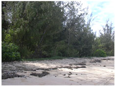
Coastal Sand Dunes |
 |
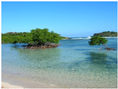
Sand dunes are formed at the interface between the sea and land. They are formed from sand which is eroded and ground rock, derived from terrestrial (e.g., glacial or river) and oceanic sources (e.g., coral reefs). The form of dune systems will be dictated by a number of factors, including the shape of the coastline, shape of the beach, currents and swell of the ocean, prevailing wind, frequency of storm events, and particle size of the sand.
|
|
Reference
Dr.Ramesh.R. and Dr.Purvaja Ramachandran. 2007,’ENVIS – MoEF on Coastal Zone Management and Coastal Shelter belt Vol(6)’,pp 25.
|
There are seven requirements for dune formation |
-
Wind
-
Sand supply
-
Topographical degree of coastal exposure
-
Rainfall
-
Plant colonization
-
Sea (wave action)
-
River mouth dynamics
|
The vegetation that is native to sand dunes is very unique and is tolerant to:
|
-
Saltwater spray from sea waves
-
Can sustain high and salty wind
-
Can stand high daytime temperatures when the sand gets very hot
-
Has special roots that can find footing even in loose sand and reach the soil underneath
|
Parts of a Sand Dune |
-
Secondary Dune-second line of dunes heading inward
-
Hollow- dry depression between dunes
-
Leeward Side- steep sloping side
-
Primary Dune- first line of dunes from the ocean
-
Inclined Windward Side- gently sloping side facing the ocean
-
Dune Base- compact base of a dune
|
One of the most important things to realize with the coastal and dune environment is that it is dynamic, like the forces that shape it, so these environments are always changing. Accepting change can be a difficult for humans to accept (such as the common perception that damage to established forest in storms is bad) but it is important to acknowledge that change is a natural and health part of this ecosystem, and helps to maintain biodiversity.
Due to the extensive coastal development that characterizes much of our beaches now, stabilization has been a large focus. This has lead to the extensive planting of marram grass that form high densely covered dunes that prevent most sand moving beyond the foredunes, affording protection to developed areas. This form of planting has proven successful for human habitation but has come at the expense of the native sand binders and associated plants. This section intends to outline the values associated with the coastal dune environment as well as the processes associated with dune building and the dynamics of the different |
Sand dune formation |
Dunes develop at the back of beaches where there is sufficient sand supply and wind energy to transport it landwards. Sand from the dry portion of the beach is transported inland until the wind energy is dissipated, or a physical barrier (such as vegetation) causes the sand to be deposited |
Coastal Plantation |
 |
Cyclones and tsunamis mostly originate from the sea and move towards the land, the wind – generated reduced, reflected, deflected and dissipated, when they pass through obstacles such as coastal forest, mangroves, offshore islands, coral reefs, head lands, sea cliffs, sand pits, mud flats, sand dunes, creeks etc.
Other than the above natural features, manmade structures along the coastal line such as offshore platforms, sea wall constructions, harbour and plantations also help in energy dissipation.
|
|
Coastal habitats such as mangroves and other wetlands, coral reefs, coastal barrier islands and lagoons are often recognized by experts as the best defenses against wind, waves and erosion by deflecting and absorbing much of the energy of winds. |
Coastal habitats such as mangroves and other wetlands, coral reefs, coastal barrier islands and lagoons are often recognized by experts as the best defenses against wind, waves and erosion by deflecting and absorbing much of the energy of winds. |
http://www.keralaagriculture.gov.in/htmle/bankableagriprojects/fw%5Ccasuarina.htm |
Casuarina |
 |
Casuarina equisetifolia is the most popular farmforestry tree in the coastal lands of Andhra pradesh, Orissa, Tamilnadu, West Bengal, Maharashtra, Gujarat & Karnataka. Casuarina resembles feathery conifer in general appearance. Almost all of the approximately 35 casuarina species produce top-quality firewood. They are rapid-growing, carefree species for sites and climates as varied as coastal sand dunes, high mountain slopes, the hot humid tropics and semi-arid regions. They tend to be salt tolerant, wind resistant and adaptable to moderately poor soils. |
|
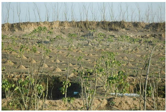
Casuarina Plantations in Orissa |
Links |
http://www.mssrf.org/tsunami/mangrove_toolkit_final.pdf |
| |
| |
Mangrove Wetlands of Orissa |
Orissa state has mangroves in about 24300 ha. The Bhitarkanika mangroves, which is the major mangrove wetland of Orissa, occupies an area of about 15000 ha and declared as a Wildlife Sanctuary. Among the Indian mangroves the highest diversity of mangrove plants occurs in the Bhitarkanika and hence, it has been identified as one of the important mangrove genetic resource centres of the world. The extent of major and minor mangrove forests of Orissa is given bellow
References:
. Selvam.,T. Ravishankar.,V.M. Karunagaran.,R. Ramasubramanian.,P. Eganathan . and A. K. Parida. 2005.
‘Toolkit for establishing Coastal Bioshield’, pp 117. |
Table Major and minor mangrove wetlands of Orissa |
| Location |
Forested Area (ha) |
| Mouth of River Devi |
346 |
| Mahanadi |
5124 |
| Bhitarkanika |
14987 |
| Mouth of River Dhamara |
2935 |
| Mouth of River Budha Balanga |
135 |
| Subernareka |
776 |
| Total |
24303 |
|
Tropical Dry Evergreen Forests of Orissa |
They occur in the drier central and western areas in parts of Bolangir, Kalahandi, Sambalpur, Khariar, Deogarh and Gobindpur divisions. Teak instead of Sal, Salia bamboo (Dendrocalamus strictus) instead of Daba bamboo, predominates in these forests. |
Phyto-sociological study was carried out in tropical dry deciduous forest of Boudh district, Eastern Ghats of Orissa, South Bolanda, Talcher, Orissa, India. The species includes Trema orientalis, Haldina cordifolia, Diospyros melanoxylon, Ixora arborea, Tamarindus indica, Chromolaena odorata, Calotropis gigantea, Woodfordia fruticosa, casearia elliptica, Phyllanthus reticulatus, Croton bonplandianus, Catharanthus roseus, Hyptis suaveolens, Solanum xanthocarpum and Tridax procumbens. Stem and leaf parts of the trees and shrubs, and whole plant of the herbs were analysed. |
Concentrations of metals were the maximum in leafy part of trees and shrub samples India. An inventory of 187 species (trees 91, shrubs 10, climbers 12 and herbs 74) within a four hectare area were made.
The predominant tree species include:
Shorea robusta
Madhuca indica
Buchanania lanzan
Cleistanthus collinus &
Diospyros melanoxylon
Located on the coastal plain of the Indian state of Orissa, the Orissa semi-evergreen forests are a tropical moist broadleaf forest eco-region of eastern India. The total area of the eco-region is 22,300 km2 and is bounded on the north and west by the Eastern Highlands moist deciduous forests. The Bay of Bengal is bounding the eco-region on the south and west. These Orissa semi-evergreen forests in India are neither exceptionally species-rich nor are high in endemism. However, they do harbour several charismatic large vertebrates of the Indian Subcontinent bioregion. The most important species found in these forests include the Tiger that is considered as the region`s largest predator, and also the Asian Elephant. Apart from that, large herds of Gaur, and one of the most dangerous mammals in the region, the Sloth Bear are also found in these forests. |
Positioned on the low hills in the northeastern Indian state of Orissa, the Orissa semi-evergreen forests are vulnerable to the full force of the southwestern monsoon winds that sweep in from the Bay of Bengal. Due to the rainfall from this monsoon and the ameliorating year-round oceanic influences, moister climatic conditions are created here. As a result, the Orissa semi-evergreen forests in India have the original extent of distinctly moister semi-evergreen forests that once existed to the east of the Eastern Ghats Mountains. The ecoregion has an ancient geological lineage of Gondwanaland origins and for this reason; it still harbours relicts of an ancient biota. |
The Orissa semi-evergreen forests in India have patches of several habitat types like the canebrakes, wet bamboo brakes, moist bamboo brakes, lateritic semi-evergreen forests, and secondary moist bamboo brakes. However, most of these habitat types are sometimes not identifiable in the field because of excessive deforestation and changes in land-use practices. The natural vegetation in the forests mainly includes five series like the Shorea-Buchanania-Cleistanthus, Shorea-Cleistanthus-Croton, Shorea-Terminalia-Adina, Shorea-Syzygium operculatum-Toona, and the Shorea-Dillenia-Pterospermum.
The Orissa semi-evergreen forests in India are also quite rich in its biotic community. The most common flora species in the upper story of these forests include the Artocarpus lakoocha, Michelia champaca, Celtis tetrandra, Bridelia tomentosa, B. verrucosa, Dillenia pentagyna, Saraca indica, Ficus spp., Mangifera indica, and Firmiana colorata, etc. The second story of the forests is characterized by the species like Aphanamixis polystachya, Mesua ferrea, Phoebe lanceolata, Polyalthia spp., Macaranga peltata, Glochidion spp., and Litsea nitida, etc. There is also an understory of evergreen shrubs, canes, and herbs present in these forests. The forests situated in the hilly areas, which have lateritic soils (the residual product of rock decay), house the species like Xylia xylocarpa, Pterocarpus marsupium, Anogeissus latifolia, Grewia tiliaefolia, Terminalia tomentosa, and Terminalia bellirica, etc.
The total number of mammal species found in the Orissa semi-evergreen forests in India is fifty-nine and none of them is considered as endemic. However, there are a number of threatened species found in the forests that need urgent conservation attention. These species include the Tiger, Asian Elephant, Gaur, Wild Dog, Sloth Bear, and Chousingha. The forests located along the higher elevations may also provide dispersal habitat for Tigers and Leopards from Simlipal in the north to Andhra Pradesh to the south of Orissa.
Apart from the vegetation and mammal species, the Orissa semi-evergreen forests are quite rich in bird species, as well. The forests are home to a large number of more than 215 bird species and none of them are considered as endemic. However, there are a few globally threatened bird species inhabit in these forests and the species include the Lesser Florican. Some of the other birds that warrant conservation attention include the Oriental Darter, Greater Flamingo, and White-Bellied Sea Eagle.
References:
tp://www.acdcindia.org/knowledgebank/Environment/PAUL-Introduction%20to%20Tropical%20Dry%20Evergreen%20Forest%20-%20TDEF.pdf
|
Coastal Sand Dunes along the Orissa Coast |
Severe cyclonic events are responsible for dramatic modifications of the landscape. The cyclone of October 1999 resulted in heavy sedimentation near the coast of Orissa the receding waters brought additional silt. Extreme events result in severe shoreline changes and hence affect coastline configuration: beach and dune erosion, modifications of dune complexes, dune breaching, overwash, inlet formation and, at places, complete elimination of sand-dune complexes is documented.
The Mahanadi delta has formed raised platform as a result of which sand dunes developed along the coast. These raised sand ridges brought changes in the drainage systems. Sand dunes are predominant in the following three sectors (Rao et al., 2008): |
|
The formation of the sand dunes can be seen between the Chilika and the Devi up to the north of Dhamra. A total of 102 species belonging to 46 genera of fungi were isolated from a coastal sandy belt of Orissa, India, over a period of 2 years, from 1989 to 1991 (Panda et al., 2006) |
Casuarina Plantations in Orissa |
-
Casuarina made inroads into coastal areas of Orissa after 1971. A severe cyclone devastated the Orissa coast in October 1971. After this cyclone, the coastal afforestation branch of the Orissa Forest Department started planting Casuarina along the Orissa coast. The objective of planting Casuarina was two-fold: to act as a barrier to cyclonic storm and to prevent beach erosion.
-
The coastal stretch particularly between the mouth of the Jatadhara River and the mouth of the Devi River has been recorded as a good sporadic nesting ground of the olive ridley turtle. Plantation of Casuarina close to the high tide line in this sector is having an adverse impact on sea turtle nesting in this area.
-
To reduce dependence on mangrove for fuel wood plantation of bamboo and coconut, predominantly, and other species such as acacia, neem, babool, eucalyptus, teak, sisso, casuarina, arecanut, on village common lands is necessary
-
Many of the people of Bandara village, of Jagatsinghpur district, Devi Mouth area, in Orissa reported a high level of dependence on mangrove resources for fuel wood till about 20 years back. Then forest lands adjacent to the village were developed with Casuarina plantations. Now the branches and twigs from these trees along with the needles swept from the forest floor are used together with cow-dung cakes and brushwood from homestead trees as fuel wood. The mangrove forests are not exploited for fuel wood. The Casuarina plantations are protected and used judiciously by the village people, even though they had difficulties in doing so, at the initial stages. Success of the protection initiative is cited by the village people as an example of their ability in managing natural resources that is important for their sustenance.
-
An artificial canal, the Palur Canal, connects Chilika Lake with the Bay of Bengal, through the Rushikluya river mouth and runs parallel to the nesting beach for about 8 kms. This canal is located to the west of the villages Gokhurkuda and Podampetta while it runs east of Purnabandha village. The northern part of the beach, has privately owned Casuarina plantations. Other flora, including creepers of Ipomea pescaprae, Calatropis gigantea and Spinifex littoreus grass help in binding the sand of the beach. The co-ordinates of the river mouth read as follows – 85o 4’ 3” E and 19o 22’ 30” N.
-
Plantation of casuarina and eucaplyptus for fencing, use as fuel wood and for house construction, on homestead lands; and jatropha as live fencing, which can also be a source of income
-
Casuarina plantations of 1954 and 1971 at Gahirmatha collapsed under the force of winds during the super cyclone of October 1999, as frontal trees did not withstand heavy winds. Similarly, post-cyclone satellite images showed partial damage to coastal trees, including mangroves in Orissa.
|
References:
http://www.keralaagriculture.gov.in/htmle/bankableagriprojects/fw%5Ccasuarina.htm |
Jatropha |
 |
Jatropha is a bush that grows wild in many places of the world. It is being touted as a potential solution to the search for new sources of energy. A genus of the plant family Euphorbiaceae; some plants contain unidentified purgatives and cause diarrhea. Includes J. curcas (physic or purging nut), J. gossypifolia (bellyache bush), J. stimulosa (spurge nettle); others cause cyanide poisoning, e.g. J. multifida (umbrella tree, coral bush).
Uses: some plants contain unidentified purgatives and cause diarrhea. Includes J. curcas (physic or purging nut), J. gossypifolia (bellyache bush), J. stimulosa (spurge nettle); others cause cyanide poisoning, e.g. J. multifida (umbrella tree, coral bush). |
|
| |